
| Identifiant | ATLAS SOMME 14-18 N°1 - 2014 |
|---|---|
| Pays | France |
| Département | Somme |
| Nom | ALLONVILLE |
| Autre appellation | N/A |
| Commune(s) | ALLONVILLE, CARDONNETTE |
| Coordonnées | 49°56’43’’N / 2°22’37’’E |
| OACI | N/A |
| Situation | 6 km nord-est AMIENS |
| Utilisation | Ancien aérodrome français puis britannique 1ère GM, allemand 2ème GM |
| Sources | • Les escadrilles de l’Aviation Militaire française 1912-1920 • Dossiers SHD série A • RAF Squadrons Site WW1 Trench maps &photos |
| Occupations successives | – Aviation française : MS 23 du 23/05 au 06/08/15 – Aviation britannique : • Sqdn 4 RFC/RAF (Morane H) du 07/11/15 au 31/01/16 • Sqdn 9 « (Bristol Scout) du 26/03 au 14/07/16 • Sqdn 34 « (BE 2G) du 16/07/16 au 31/01/17 • Sqdn 53 « (RE 8) le 23/03/18 • Sqdn 82 « (AW FK 8) du 24 au 26/03/18 • Sqdn 80 « (Sop Camel) du 31/08/18 au 07/09/18 • Sqdn 203 « ( « « ) du 14/08 au 05/09/18 • Présence RAF au 19 / 11 / 18 • Présence du 148 Aero Sqdn US du 11 au 18 / 08 / 18 Infrastructures : 6 hangars RAF simples en juin 1917, 2 en novembre 1918 |
| Fiche mise à jour | 09 / 16 |
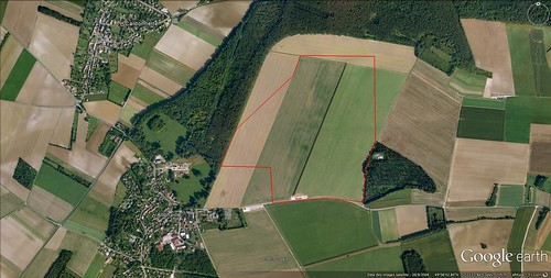
Position et limites du terrain (Jacques Calcine, membre 2A, thanks to Roger Austin, RAF))