
| Identifiant | ATLAS SOMME 14-18 N°1 - 2014 |
|---|---|
| Pays | France |
| Département | Somme |
| Nom | LÉALVILLERS |
| Autre appellation | N/A |
| Commune(s) | LÉALVILLERS |
| Coordonnées | 50°03’19’’N / 2°30’28’’E |
| OACI | N/A |
| Situation | 12 km Nord-ouest ALBERT |
| Utilisation | Ancien aérodrome français puis britannique 1ère GM |
| Sources | • Dossiers SHD série A • RAF Squadrons • Site WW1 Trench maps &photos Les escadrilles de l’Aviation Militaire française 1912-1920 |
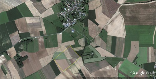 Limites du Terrain (Jacques Calcine, membre 2A, thanks to Roger Austin, RAF) | |
| Occupations successives | Sqdn 15 RFC (BE 2D) du 02/10/16 au 05/06/17 Sqdn 32 “ (DH 5) du 25/10/16 au 02/07/17 Sqdn 41 “ ( “ ) du 03/07 au 21/03/18 Sqdn 59 “ (RE 8) du 22 au 25/03/18 Infrastructures (07/17) : 3 Bessonneaux, 3 hangars RAF simples. |
| Fiche mise à jour | |